23 May - 2 June
Arden Valley Road, NY -- Port Clinton, PA
23 May 2005 (Monday) Wildcat Shelter, NY
Back on the Trail again! Ann dropped me off at Arden Valley Road (where it – and the Trail – crosses the New York Thruway to the west of Harriman State Park) at noon. It’s been a forgetful day in ways: first, I left my bamboo hiking pole at home; then, I forgot to ‘camel up’ from the extra bottle of water I’d put in the car; and finally, I forgot that I’d already done a few miles of the AT south of Arden Valley Road (maybe 3 miles or so, which I recognized when I was on it, back in 2002 or so). Other than that it’s been nice.
A little slow, perhaps, taking over 6 hours to come 10 miles.
It was pretty overcast all the drive up from home, and for 3 hours of hiking, but at 3:00 the sun came out and it warmed up a little (past the 56 degrees it was in the early afternoon).
Some native wildflowers along the way today, including this pink lady's slipper orchid just within a foot of the Trail.

Two folks here at the shelter when I arrived: a young girl named Odessa (she said it was because she was a Classics major in college) and an old guy (quite talkative) whose name I didn't catch, both going north. Two others showed up since, but they’re tenting. Then a guy and dog (guy in a skirt, dog with a pack), but they’re tenting somewhere, too.
It’s 8:45 and about 60 degrees. Pretty much time to go to bed. Odessa already has; guy seems about to be; tenters are sitting on the bench at the shelter fire ring chatting, eating, and looking at pictures on his cell phone.
24 May 2005 (Tuesday) Waywayanda Shelter, NJ
Cold day on the Trail. [Click image to see full size]

Overcast all day except for one very short outbreak of sun at 2:00. Hiked from 7:30 to about 2:30. I’m sure it wasn’t above 60 all day. At least it didn’t rain.
[Click image to see full size]
Crossed into New Jersey in the afternoon, so now I’ve done all of the AT in New York, too.
Played “leap frog” with the guy and dog. He introduced himself where they had stopped at one of the creeks we crossed as Jill (or, would it be Gilles?), then spoke to his dog “Here, Jack.” I said, “Oh, I get it: Jack and Jill. And you’re fetching water, too. What are the chances?” He said that when he started in Georgia he was carrying a small pail, too. Why not? They’re in the shelter tonight, too.
It’s only 4:50 and I’m done eating, put food in the “bear box” [a metal foot locker with a hasp on the front that’s supposedly bear proof], and have gotten into my may to warm up some.
I didn’t do any great thinking today on the Trail. Considered a little some of my regrets … what they might be. Like not having had the courage to through hike back in the 1970’s. Or not having taken batter advantage of New York City in all those years of living in Tuckahoe. Or not having really nailed my languages back in college. Missed opportunities all. I don’t want to have any more.
47 degrees at 6:00 pm. In my sleeping bag. Still warming up, because I’ve got my shoulders out. Can’t do crosswords or read comfortably.
Tomorrow’s start should be easy. After that, probably not too hard, it looks.
25 May 2005 (Wednesday) Pochuck Mountain Shelter, NJ
Another chilly day. Overcast all day, breezy, last night’s rain blowing off the trees especially in the morning.
I left Waywayanda at 7:00 and got here at 2:00. Seven hours for 12.3 miles (or something like that), but that includes 2 stops for water which are, of necessity, a little longer than 10 minutes each. It’s sometimes hard to stop and all when I’m chugging along, but I’ve skipped water sources before and regretted it later.
Today’s hike was mostly not too bad. Came down off one mountain on a long series of stone steps. And in the last mile there was a serious rocky patch. But in the middle, some flat areas traversed on puncheon and by the new boardwalk and bridge just put in last summer (or was it the one before?).
I saw some pink lady’s slipper orchids today, so I’ve seen at least one each day. And I think I heard a winter wren today. I’ve also heard veeries singing a few times.
Got one set of clothes hanging about various places in hopes that they’ll dry out before nightfall.
[Click image to see full size]
Pretty sweaty despite the chill. I didn’t check the temperature in mid-day, but right now in the shelter it’s 53 degrees – minus whatever the wind chill is.
A couple young guys showed up last night shortly before dark. Turned out to be people Jill had known back around the Smokies or before. I enjoyed listening to their chatter about who is on or off the Trail, and their recommendations to Jill about places to stay in Pennsylvania. Jill, it turns out, had started at Springer, hiked to about Harpers Ferry, gotten off to go to a wedding in Connecticut, decided to hike south from there, and is planning on jumping then from Harpers Ferry up to Connecticut to head north to Katahdin. He explained to his friends that it’s a ”kilt” not a “skirt” (even if it is a plain khaki color, not a tartan).
Tomorrow I have some elevation gain to make. The goal is High Point Shelter (near the highest point in New Jersey), but I think I might go a little beyond to Rutherford Shelter and then bump the next day on a little, both in order to shorten the scheduled 21 mile day on Saturday. I’m supposing it will work. I could have done 5 more today and still been in before dark. Least ways I feel like I could.
8:45 pm and time to turn in. Temp holding steady at 49 degrees last couple hours.
26 May 2005 (Thursday) Rutherford Shelter, NJ
[Click image to see full size]
So when I got to High Point Shelter it seemed too early to stop. It was only another 4+ miles to get here, so I did.
That was despite the suggestion of the creator/host of “The Secret Shelter” who told me that “it’s in a swamp,” likely to be buggy, and that he always suggests people push beyond it. I’d also met a NO-BO hiker named Chino – who recognized me from down south – who was here last night. He told me that “while it’s .4 miles off the Trail, it’s an easy .4.” The first tenth of a mile is actually a pretty steep drop down from the AT. I think that’s the big reason it doesn’t get a lot of overnighters. (It couldn’t be the phoebe nest with babies in the front overhang.)
Tonight I ate the “Flyin’ Bryan’s Garlic Potatoes” meal I got from the “Lipsmackin’ Backpackin’ Vegetarian Cookbook.” And to make things eerie, Flyin’ Bryan had actually signed the shelter register some months ago.
I called home from the High Point State Park office at 3:00, but had to leave a message. Since I was scheduled to have stopped 2 miles short of the office, I’m sure Ann wasn’t expecting a call.
Saw another pink lady’s slipper today.
This was another overcast, cool, damp day. Maybe the sun will come out next week. There was a lot of grassy field to walk through early this morning. It’s amazing how wet boots and pants get just walking thru a field. I’ve got my clothes hanging up to air out, but I’m certain they won’t dry.
I was alone at Pochuck Shelter last night and probably will be again tonight.
6:30, 58 degrees.
27 May 2005 (Friday) Brinks Road Shelter, NJ
I wasn’t alone last night after all. AND it was sunny all day today! Woke up at something like quarter after five and saw a bright moon shining through the trees. Seemed like a good omen. And it was, for 30-45 minutes later I could tell that the sky was blue. Just now at 5 pm a thunderstorm rolled in from somewhere, but I’m under a roof and that’s fine with me.
Saw two more pink lady’s slippers today. And my first real snake: a 5-51/2 foot long black snake which zipped for cover when I came upon it. Took a photo, but only got the front half of the snake in the frame.
The Mashipacong Shelter is the first place I saw some of Desperado’s trail magic. He takes care of a few shelters along here and stocks the bear boxes with goodies: lemon cookies, drink mix, first aid stuff, alcohol for fuel. The cookies were gone when I got there, but I took some fuel because I was concerned about getting through another week with what I had. Their privy is also a large metal shed over a composting privy, a commercial design; quite nice. [Click image to see full size]
I passed by the Gren Anderson Shelter because it was a little off the Trail, so I don’t know if Desperado stocks goodies there. I’d been scheduled to stay there, and had wanted to see it because it was built by Green Mountain Club members. Here at this shelter, though, I was able to partake of the lemon cookie gift. Makes up a little for the Worthington Bakery being closed. (Am I the only person on the Trail who didn’t know that it wasn’t open for business any more? There were constructions guys all over it doing remodeling, so maybe later this summer.)
The water at this shelter is down a blue blaze trail that disappears. I got off track coming back and the next guy got further off – had to holler for his wife to find his way back to the shelter. They’re from Mississippi. Talked to her a bit while he was getting the water, and she said that she’s doing this for him; and hopes her turn will come. They’re tenting.
Two young folks showed up and there was another younger guy (from Tennessee) already in the shelter when I arrived
As I was approaching the closed bakery today I met a guy on the Trail who had just started. His clothes were too clean, for one thing. He said he was headed for the Water Gap – so I turned him around and headed him south. We walked together to the road and he didn’t see the blaze there (okay, so it was a little hard to spot on the back of a sign) so I led on [wondering later whether I should have gone on down to the gas station I saw and gotten a soda as least – it was still hot then – or looked for a phone, or more water]. We hiked up the hill and he was telling me a story about getting lost once in the Smokies with two rock climbing friends, and we missed a turn while he was talking. I realized it a couple hundred yards down the hill on the woods road we were on (the down hill part should have tipped me off earlier), and turned us around. Up the next step part I told him “any time you want to pass me.” He said I was setting a good pace. When we got to the real top he took a picture of me eating the second of the chocolate-y granola bar snacks he’d given me, with a nice big vista in the background. He’d been telling me about his work doing something engineering rail trails, and how this part of New Jersey has a lot of lakes. Then he led off. And left me in the dust. “Good pace” indeed! Last time I saw him was about 10 minutes before getting to the shelter when I spied him up ahead a ways hoisting his pack after a break. He’d said to someone we passed that he was aiming about 6 miles beyond the shelter, but all my data book shows thereabouts is a road. Well, whatever.
Another guy showed up while I as writing that paragraph. I’m thinking they’re starting long holiday weekends. It is Memorial Day on Monday, right? I think they’re all tenting.
I’ve got 5:30 and 65 degrees.
Oh! First real trail magic was yesterday. I came down some hill to some unmarked (gravel, as I recall) road. Saw some ‘trash’ to the side of the Trail: two cardboard cases for beer. But something made me go over and check them. One had unopened cans (at least 2) in it! So I washed one off, popped it open, and drank down all those lovely carbohydrates. Quite unexpected, unmarked, and unreservedly appreciated. (Except that in the last day I found myself wondering whether I should have brought another can along with me. Ah well, share and share alike.) Time for dinner, I guess.
There’s another phoebe nest here in this shelter.
28 May 2005 (Saturday) Mohican Outdoor Center, NJ
Today was a good day on the Trail. Weather was nice, starting sunny and getting cloudier in the afternoon. Then just beginning to sprinkle as I was within the last mile of this place.
“This place” is the Mohican Outdoor Center, owned and operated by the Appalachian Mountain Club ( a little south of their usual stomping grounds). It’s got cabins and tenting sites and a couple buildings for groups. I’m in one of the latter and the check-in guy said there were only 2 other peoples here (so far) in this building. AND, I scored a single room rather than having to share bunkbeds in a room of 6 or 8. I got here about 3:30, I guess; checked in and picked up my re-supply box; walked down here to this building; read Ann’s letter (which was in the box); took a hot shower (!); and made supper. There’s a kitchen here, so I used their electric stove to heat my water. Same meal-in-a-bag, but sitting down at a table indoors under fluorescent light does make it nicer. (Here come the other folks.)
The 14 miles I did today were split right in the middle as a road crossing that had a water pump at it. Made it easy to stop for “lunch.” A couple handfuls of gorp. And it seemed like a lot of the Trail was fairly flat today, too. Some was actually abandoned asphalt road (now turned to gravel) from a vacation community bought out by the federal government when they were talking about damming up the Water Gap.
I go through the Delaware Water Gap tomorrow. It’s 10 miles or so from here to the west end of the I-80 bridge over the river. Then another 6.6 miles up to the shelter. Shelter’s at 1,500’ elevation. Bridge is at 350’. I should be going through the DWG right around noon and will dicker with myself about getting a restaurant meal. May depend on the weather somewhat.
A couple people mentioned to me that the worst of the fabled Pennsylvania rocks are between here and Wind Gap. I pass Wind Gap on Monday.
This is the first day I didn’t see a pink lady’s slipper.
Before I forget, more wildlife: ticks! Either the shelter had them last night or I brought them in with me. Killed 10 or 11, and 5 or 6 were actually on my legs, though not yet settled down for a meal. I got one more this afternoon off my calf when I took my boots off. And then two more in the shower. Had trouble getting to sleep last night, too, as a result. First some mosquitoes and, then when the cooling temperatures sent them on their way, thinking that every itch or tickle was another tick. Two or three times during the night I did pick something off me and toss it out of the shelter. I should have turned on my flashlight to see if it was tick-ish or not. The other guy in the shelter was sleeping soundly even though he had a very noisy air mattress. Actually, he was in his sleeping bag when I arrived, only got up to make his supper at one point after I ate, and went back in the bag right away. He only barely got up before I left this morning. He’s heading up to Hanover, NH (like the guy I was with the night before) where he will finish his AT hike.
It’s 6:00 and still raining. I’m going to get on a pair of dirty pants (so my clean ones will remain my “dry clothes in case of rain” pants) and go back to the lodge building to see about a phone and a candy bar.
29 May 2005 (Sunday) Kirkridge Shelter, PA
Ended up last night that there were probably 10 or more people in the building. Including 4 who were up and loud until 9:30. Posted quiet hours were from 10 pm on, but sheesh …. I was trying to get to sleep from 8:00 or 8:30, when it was getting dark outside. I think they might have been the same four kids who showed up at the Brinks Road Shelter at 9:30 that night, headlamps ablazing. They looked around and, deciding there weren’t any good tent sites there, walked back up the blue blaze to the AT. I found them in two tents at the junction with the AT when I started out in the morning. Their bear bags were hung about 4 feet off the ground.
I ended up sleeping pretty well in the end, though, and getting up just before 6:30. Ate, packed, and left at 7:30.
Had something of a long day. Sunny mostly until about the last 2 miles of 16. Went 10 miles to the Delaware Water Gap visitor center which was roped off and closed due to a flood some time back. I rested and ate some gorp there. Then walked over the bridge into Pennsylvania. (And didn’t think about it being the completion of another state until later.)
Tried to get a meal there in town at the Trail’s End Café, but after leaving my pack outside and reading the menu while waiting to be seated for the Sunday brunch, I noticed the sentence beginning “While we do not take any credit cards ….” Well, shoot! I really should have put last night’s room on the plastic and kept my cash. So, rather than walking further into town for an ATM or someplace taking plastic, I went on up the hill. Wonder what would have happened if I hadn’t seen the notice. Would they have held my pack hostage while I went for cash? Or had someone drive me to an ATM?
It turned out okay. It was starting to rain the last couple miles and I really bore down to make it to the shelter before it let loose. Might have been in more rain if I’d stayed and eaten something in town. Here at the shelter are 2 women with 2 high school girls (and I can’t figure out the relationships) and 3 college freshman guys, former boy scouts, who are not with the women. One of the guys mentioned “up at Saranac we …” so I asked him if he meant Young Life’s Saranac Village. He did indeed. He’d been there three summers in a row. I told him I was on the first work crew of the second summer it was open.
Saw another pink lady’s slipper today.
There were mega rocks around Sunfish Pond, the other side of the Water Gap. A real boulder scramble in places. [Click image to see full size]
PA doesn’t have all the rocks. People keep talking about the rocks and the register here is full of NO-BO remarks about being glad to be getting out of Pennsylvania. Guess I’ll find out how they rate in my own mind tomorrow. (There are also a few comments about how the rocks “weren’t as bad as advertised.”)
Met the Ridgerunner as I was entering DWG. He was closing in on the bridge and I told him “There’s a straight flat stretch up ahead with no rocks”
and then saw his ridgerunner patch. We chatted a bit. He didn’t know how the food was at the Trail’s End Café and suggested pizza or donuts in town. And didn’t know absolutely that the water up here was working. It’s piped in from a retreat center just in back of the shelter a short walk, and was reported to be out of service early in May.
Ann and I had a nice talk last night. She’s planning on hiking in to the last shelter and spending the night with me on Thursday.
It’s cleared off a lot and is probably 60 degrees here at 7 pm. Food is hung since there’s an apparently recent notice in the shelter about bears nearby.
30 May 2005 (Monday) Leroy A. Smith Shelter, PA
Well, so far, my home state is living up to its “Rocksylvania” moniker. There was a long, fairly straight, relatively level, and very slow and tedious stretch today. All because of those rocks. One really can’t look up very often; and there’s no place flat to place one’s feet. But it’s supposed to get better the further “south” I go.
One remarkable thing about hiking today is that I didn’t see a single hiker going either direction. I did pass two groups of campers who had hiked in to their camp sites (one family of 4, and one group of 3 Army guys), but since they weren’t hiking a the time I’m not counting them.
When I got to the shelter here I thought there were hikers in ahead of me, but they turned out to be 2 locals coming up the mountain for a holiday view from the top (this shelter is on a trail that heads down the side of the ridge to civilization someplace, and it’s near a power line crossing). They offered me food – Swiss cheese and granola bars – from their small picnic cooler. We chatted a bit and then I went off for water (a 10 minute walk each way). When I got back they were gone, but had left another granola bar for me. I took off my boots and put on my long-sleeved shirt against the chill of the sprinkle starting up. It rained in fits and starts. Then the people showed up again, having just gone up to see the view from the power line cut-through. We chatted a bit more, but they didn’t offer any more edibles. (I thought later I should have thanked them again for the food and mentioned that I hoped I didn’t seem greedy because I sure felt like I could have eaten a lot more.) Then they left. Rick and Maggie: they left a note in the register saying something about being under God’s almighty care, but faith didn’t come up in our conversation.
I did do more thinking about faith while walking today. It’s hard for me not to with the last phrases of the Te Deum ringing in my head for miles after my morning trail devotion (“Day by day we magnify Thee; and we worship Thy Name ever world without end.”) Just how do/should/can I magnify God day by day?
Through the tedious part of the Trail, though, I was mostly imagining what if I’d sat down to rest on some rocks, gotten bitten by a rattlesnake, got it off me quickly, killed it, taken its photo, and had to stat out for help. Somehow I’d have a cell phone and would be carrying on one of those long off-and-on calls to 911 that get written up in a Reader’s Digest story. Today, anyway, there wouldn’t have been anybody ‘coming along before too long’ to go for help after the venom in my leg made it impossible to get very far very fast (plus, remember all those rocks). It would have been sad, and nearly tragic. I ended up awakening in a hospital room, so I guess I made it out alive somehow.
I made it out of the shelter at 7:15 this morning. Good thing, too, judging from the timing of the afternoon rain showers (which seem to have stopped for now at 7:00 pm). The women and girls were all asleep or pretending to be. (Turns out that they were indeed Girl Scouts.) The three guys hadn’t emerged from their tent. I made breakfast, took two trips for water, packed up and set out; none of the rest appeared to move at all.
Yesterday another NO-BO recognized me on the Trail. This was “Metric” who was one of the 3 guys at Manassas Gap who identified the “Foe-bee” nesting in the overhang. And in the registers yesterday and today, I see that a couple other hikers I chatted with, “Chestnut” and “Palladin,” have already passed this way.
Here’s what may be a “first appearance in print”: in an article by Matt Heid (Senior Editor of AMC Outdoors) “Sticks and Stones; the pros, cons, and proper use of trekking poles” in AMC Outdoors Magazine April 2005, pp.14-16, is this sentence: “An informal poll conducted by the Appalachian Trail Conservancy in 2000 indicates that 90-95 percent of Appalachian Trail thru-hikers carry trekking poles, as do 30-50 percent of short-term backpackers, and 10-15 percent of day hikers.” And the name change doesn’t become official until the meeting in July.
7:20 pm, 58 degrees, time to read.
31 May 2005 (Tuesday) George W. Outerbridge Shelter, PA
[Click image to see full size]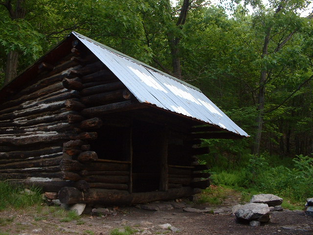
A good, long day of strenuous hiking. Some up. Some down. Some flat. Some rocky. Some not.
No pink lady’s slippers today, but I did get to hike over and through and down the Palmerton Superfund site, a former zinc mining and smelting area that looks like a cross between a moonscape and some Death Valley scene of desolation.
[Click image to see full size]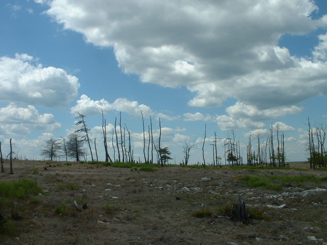
Even had buzzards circling overhead. Only thing missing were the sun-bleached remains of a broken down Conestoga wagon, and the whitened bones of an ox or longhorn cattle or whatever.
Before descending the huge rock pile to the river in Lehigh Gap there’s a long flat walk up on top (mostly on an old road).
[Click image to see full size]
Up there I met 3 kids slackpacking north – “the B’s” and “Hippie Longstocking.” I’d heard of all three before, mostly from register entries. They explained what I’d heard last night from the late-arriving group “The A-Team, that a group of about 15 NO-BO hikers had kind of clumped together, shelter by shelter through much of Pennsylvania, but had taken three zero days over the Memorial Day weekend to go to someone’s house in New Jersey. It sounded to me like it might have been Hippie L’s house, because she described its features and attractions “for that crowd” knowingly: hot tub, showers, bar, phone, cable modem Internet connection, washer and dryer ….
That “A Team” group came into the shelter after I wrote last night. During the heavier rain (which it looks like we won’t get any of tonight). I think they’re a guy, his sister, and her boyfriend. The latter two were cooking together, then turned the stove over to the brother to cook his meal separately. They, too, were coming off a couple day’s holiday with parents (the parents, by the way, signed in at tonight’s shelter register a few days ago). The girl was definitely running the show, and asked me questions about the Trail up ahead. The guys both admitted not really having heard about the Trail until some 6 months ago when she talked it up with them and convinced them to come. They started 13 February. She told me that she was a super-organized person and had started out with a schedule … which she quickly threw out. They were a little interested in the different outlook of section hikers. The boyfriend wondered how I could ever get back to hiking again once I’d get off for such a stretch; he imagined that if he stopped for months, he’d never go back to the Trail.
Between 6:45 and 7:00 tonight three guys showed up for the night. 7:14 and 71 degrees.
1 June 2005 (Wednesday) Allentown Hiking Club Shelter, PA
[Click image to see full size]
Another long day, but not so bad hiking. There were a couple places where there were real serious scrambles, needing focus and concentration (and no rain!), but a lot of today was pretty flat stuff, some of it even rock free.
My own highlight of the day came 4 mile from the end, where I crossed route 309. I toddled over to the combination restaurant and B&B to see whether they really do have water available as the guidebooks say. Well I couldn’t find an outdoor tap that was working, and the place was locked up tight. So I toddles back across the big parking lot to the Trail crossing. There were two truck drivers parked in the lot, hauling stuff to make or repair highway guardrails and one of them called over to me. We chatted a bit and she wanted to know why I did it, how far I’d come, and so on. Then she asked me if someone was supposed to be picking me up. No, I said, I was just hoping that they had some cool water to spare; and waved my empty water bottle. No problem, she says, and grabs a gallon jug of spring water from the seat beside her to fill up my empty liter. We talked a little more and she asked what I ate along the Trail. As I was explaining my trail food, the other driver’s cell phone rang and she called over to us that they were ready down at the job site. SO then my driver says, here’s some bread (a big roll) and some butter packets for your lunch. She also topped off my water bottle. I told her she was an angel. And we went our separate ways. Real “trail magic.” (Okay, maybe bread and butter and water doesn’t sound that exciting to you, but it really hit the spot with me at that moment.)
I saw a turkey cross the Trail this morning. And last evening there were two scarlet tanagers. Oh, and how can I forget at 4:38 this morning a whip-poor-will very near the shelter?
Last night there ended up being only two other hikers at the shelter with me. A third guy was there for maybe half an hour before pushing on (into Palmerton?). They were all very interested in my lurid tales of the size and difficulty of the Palmerton superfund hill. I showed them a couple of the photos I took, too. A couple of the guys gear talked for a while before the one left. Then there was some amiable chatting for a while.
The older of the two, “Buzz,” really hates the rocks, which are doing a number on his knees. The younger guy, “Catnip,” was maybe even still in high school, wearing a feather in his hair, and section hiking Harpers Ferry to the Water Gap. He seemed to subsist on snacks, and was hiking in his old skate-boarding shoes. He told me this morning that he ate only dry food and thought that maybe next time he’d bring a stove and cook some dehydrated food because the dry stuff just weighed too much (or maybe it was the other way around, I don’t remember). I didn’t pursue with him the essential differences between dried and dehydrated. Buzz, by the way, had left Springer on the 15th of March, a full month behind the A-Team, and now only a day behind them. Shows the power of taking zero days; he’d only taken 3 since he started.
Between the whip-poor-will and all, I was on the Trail at 6:45 this morning. Got in here at, I think, about 4:45. It’s a long hike for water. Their sign says 1,200 feet … which I figure is close to a quarter mile, but the “feet” make it sound closer. Took me ten minutes to hobble down to the spring.
It’s 7:45 and 71 degrees. We’ll see whether anyone else shows up.
Tomorrow I meet Annie, either on the Trail or at the shelter. It’s another 16 ½ mile day for me (plus a water run in the morning).
2 June 2005 (Thursday) Windsor Furnace Shelter, PA
Nobody else showed up last night. It’s a relatively new shelter, with a nice privy and all. And a spring almost a quarter mile away. Someone had left a plastic gallon jug in the shelter so I used it this morning to get my water, and was able to purify it all at once, drink a couple liters, and still have my water to carry with me when I headed out.
There was what seemed like a really long uphill along a road in some state game lands this morning. Pretty easy trail because it was a maintained gravel road, but constantly uphill. And the blazes not too close together so I kept wondering whether I’d missed a turn off. Eventually the road petered out, though, and the Trail reverted to ruts and rocks.
Pretty much all day there were only 3 day hikers, without even day packs. Two were before this long stretch and one was during. The last guy was pretty talkative and told me about seeing a rattlesnake up at “The Pinnacle,” a high point I was heading for. When I got there I didn’t see any snakes, but then I didn’t go out to the overlook either. From there on, the Trail was more “normal.” Well, except for passing a radio tower where I could hear the air conditioning kick on for the equipment.
Eventually, though, when I think I was about within a mile of the shelter, I spied Annie up ahead. How nice! We walked to the shelter together, sharing our day’s experiences (mine included seeing one of those grouse play the broken wing game to try to lure me away from her ground nest and babies). We rested and then had supper. Ann also brought Snickers and Butterfingers, enough to satisfy and have many left over to leave in a plastic bag for other hikers.
While we were resting and snacking a hiker came up to the shelter to write in the register. She looked vaguely familiar, like I’d seen her in Virginia, but her name didn’t ring a bell and we didn’t put together where we were when exactly. She was heading north and said something about 10 more miles before dark, which seemed an awful lot to me with what daylight was left to her.
I’m thinking that, just 6 miles north of Duncannon, this shelter doesn’t get lots of overnight traffic.
Oh, another example of NO-BO prejudice: just before the last road I came to (where the long uphill through the gamelands started) I came across a sign facing south that read “Ecologically sensitive area; no camping for next ½ mile.” So, if I’m coming from the other direction like I was – where there is no such sign at the end of the sensitive area – and I decide to camp within a half mile of the back side of that sign … am I still liable for disturbing the area? It wouldn’t be that big a deal to put up signs for SO-BO hikers, too, would it?
10 June 2005 (Friday) home
This would have been my final day on the Trail if I’d been able to keep hiking south in Virginia. Of course, things turned out well anyway. I was able to be home to get an important phone call; got some chores done; got a lot of good reading done.
And I basically filled in a long “gap” on my trail map. Now all I really have left is Connecticut and Massachusetts; everything south of Thornton Gap, Virginia; and north of Pico/Killington, VT. Simple.
Ann and I had a wonderful night in the shelter and the hike out in the morning was not too bad (from my point of view) except for a persistent drizzle. Didn’t take too long to drive home from there. And I start back at work on Monday.
The "math":
166.8 Trail miles in 11.5 days for an average of 14.5 per day;
total (with earlier in May hike) of 291.8 miles over 19.5 days for an average of 14.9 miles a day;
finished AT in New York, New Jersey, Maryland, West Virginia, and all but about 20 miles of Pennsylvania; also have the southern 100 miles of Vermont done